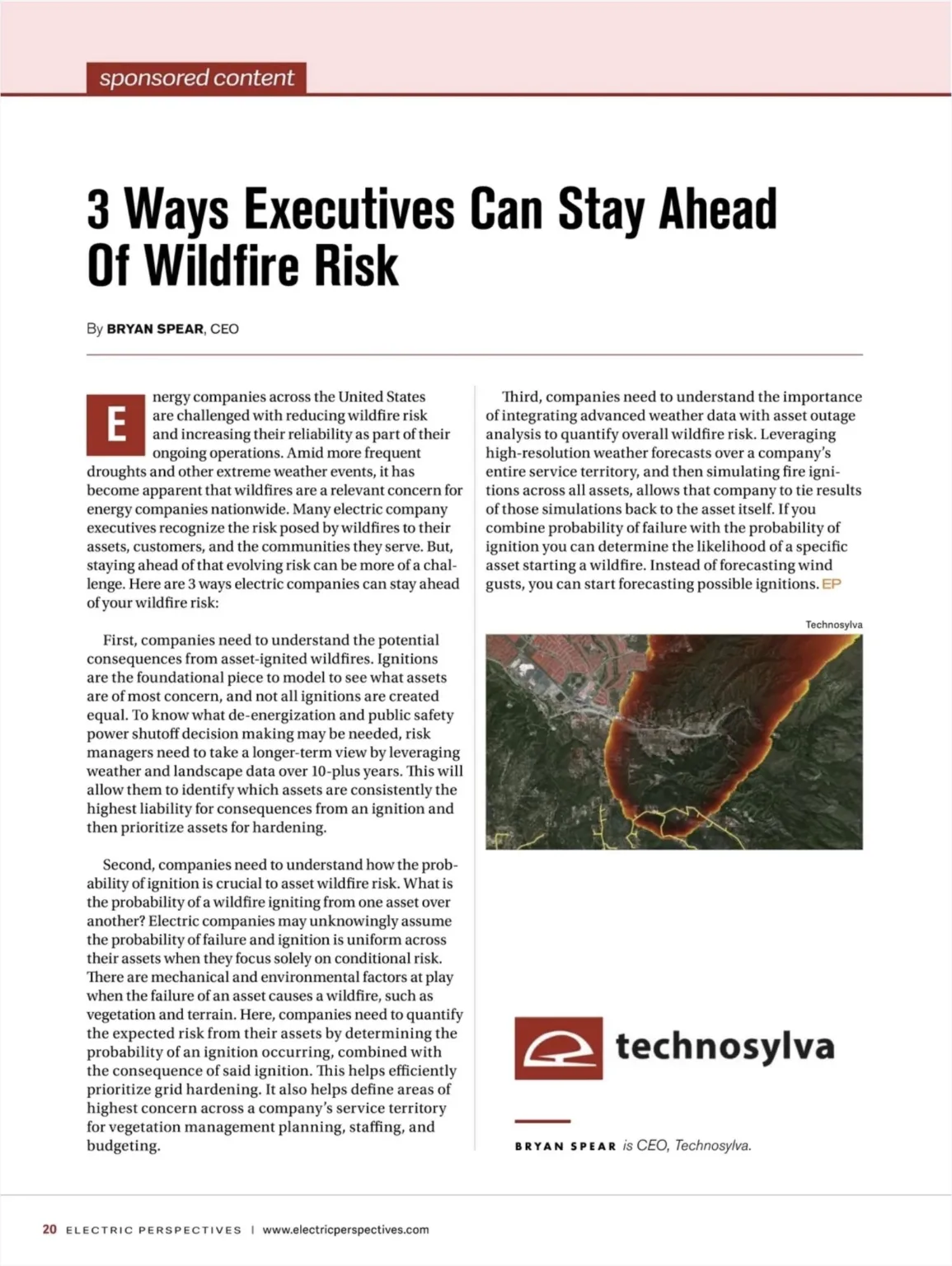
Article
Are you Forecasting and Managing Actual Wildfire Risk?

To protect infrastructure and communities in an increasingly wildfire-prone environment, utilities need a new approach.
Knowing that conditions are hot, dry, and windy is useful. But for an electric utility trying to protect its infrastructure and the communities it serves, it is not enough. Weather conditions describe the environment. They do not tell you which of your assets is most likely to cause an ignition, where a resulting fire would travel, or how many people and structures could be in its path.
That distinction, between knowing conditions and understanding consequence, is at the center of how leading utilities are rethinking wildfire risk management.
The Limits of Weather-Centric Risk Assessment
Red Flag Warnings and standard weather forecasts are essential inputs for situational awareness. No utility should ignore them. But they were designed to serve a broad public safety function, not to drive circuit-level operational decisions.
The core limitation is one of translation. A forecast tells you that wind speeds will reach 40 mph and relative humidity will drop to 10 percent. What it does not tell you is which specific assets in your service territory are most exposed under those conditions, how a fire starting at any one of those assets would behave given local fuels and terrain, or what the potential impact to structures, roads, and populations would be if that fire spread.
For utilities of any size, making operational decisions without that layer of analysis means working with incomplete information. For smaller utilities with limited staff and budgets, it also means that every response, whether deploying crews, initiating a PSPS, or accelerating vegetation management, carries more risk of being either too broad or too narrow.
What Consequence-Driven Risk Assessment Looks Like
The utilities closing this gap are doing so by integrating weather forecast data with fire behavior modeling that is specific to their service territory. Rather than waiting for a warning and then reacting, they are running simulations days in advance that account for forecasted weather, local fuel moisture and fuel type, topography, and asset locations.
The output is not a general risk level. It is a granular, asset-by-asset view of where ignition potential is elevated, where a fire starting from a specific asset would likely spread, and what the potential consequences of that spread would be in terms of structures, population, and infrastructure at risk.
That level of specificity changes how decisions get made. A utility that knows three specific circuits in its territory will carry elevated ignition risk on Thursday can pre-position crews, prioritize inspections on those circuits, notify affected customers, and make a more informed and defensible PSPS decision if conditions warrant it. A utility relying on a regional weather warning alone is making those same decisions with far less to stand on.
Turning Data into Actionable Intelligence
One of the practical challenges utilities face, particularly smaller ones, is aggregating multiple data streams into something their operations teams can actually use in a compressed decision window. Fuel moisture data, weather forecasts, fire spread simulations, asset risk ratings, and impact estimates all need to come together into a clear, current picture of where risk is concentrated and what the appropriate response is.
Leading utilities are consolidating this information into unified risk views, sometimes described as fire size potential maps or daily risk forecasts, that give operations teams a single point of reference for decision-making. The goal is not more data. It is faster, clearer answers to the questions that matter most: where is risk elevated today, which assets are most exposed, and what should we do about it.
This approach also supports longer-term planning. When a utility can see patterns in where risk concentrates across multiple forecast cycles and historical seasons, that data becomes the foundation for smarter vegetation management prioritization, more targeted asset hardening investments, and more credible wildfire mitigation plans submitted to regulators.
The Bottom Line
Every utility operating in wildfire-prone conditions, regardless of size or geography, needs to be able to answer a basic question: if one of our assets caused an ignition today, where would that fire go and what would it affect?
If the answer relies primarily on regional weather warnings, there is a gap worth closing. The technology and data to close it are accessible to utilities of all sizes. The utilities using it are not just better prepared for the next high-risk day. They are building a foundation for every operational and planning decision that follows.