-
Technosylva Takes the Science to the Hands of the Firefighters in the Field
Accurately predicting fire spread and behavior on the fire line, where reception for data connectivity is difficult, is highly important. This ability can prevent the loss of human life, improve the success of initial attack, and lead to better understanding of the potential fire behavior that minimizes many risks for firefighters.
To address this, Technosylva led a 2018 peer-reviewed study, published in the academic journal, Ecological Modelling, validating how Technosylva’s Wildfire Analyst™ Pocket Edition leverages well-known mathematical models in the scientific community to achieve this field operations goal. The platform allows firefighters to input data and receive real-time information on fire characteristics and estimated progression, all in a user-friendly 3D map interface.
“This is where we demonstrated that we can, as a technologist, bridge the gap and show what the role of technology can be to the wildfire community. What we did with this firefighter-focused application was to apply all the complex models in our lab and put it into a small application that is free for end-users in the field. This once again highlights Technosylva’s goal of being the bridge between scientists and technologists. The application is very popular for firefighters in the field, with over 11,000 downloads, and is being used officially as part of the NWCG S.130 wildfire training course to advance the risk understanding of future wildland firefighters.”

Joaquin Ramirez, Ph.D
Co-Author – President & CTO
Insight from the Research
The analysis looked at the importance of predicting fire spread and behavior in wildfire management and highlighted a mobile app called Wildfire Analyst Pocket, or WFA Pocket, which is designed to provide real-time analysis and predictions for wildfires. Let’s break down the key points in a conversational summary.
Fire modeling systems, which estimate fire behavior, are crucial for fire management agencies at various levels, from global analysis to local fire assessment and prescribed burns. These fire simulators predict fire spread and behavior under various conditions and provide valuable data for experienced fire managers during firefighting, prevention, and planning efforts. Several established fire simulators have been developed over decades, such as Farsite, FlamMap, BehavePlus, and Wildfire Analyst (WFA).
WFA is a software designed to provide real-time analysis of wildfire behavior and spread, supporting decision-making during firefighting operations. It offers a wide range of data, including fire perimeters, flame length, rate of spread, and more, tied to weather conditions and input data.
Accurate predictions of fire behavior are crucial for preventing loss of life and minimizing damage during wildfire incidents. However, due to a lack of computer access on the fireline, fire agencies couldn’t use these fire simulators effectively.
In response, the Wildfire Analyst Pocket Edition (WFA Pocket) was developed as a mobile app for field use. It aims to estimate fire progression and behavior based on observed conditions, using well-known fire spread models from BehavePlus. This paper describes the development, design, models used, and the primary features of WFA Pocket.
WFA Pocket works on various devices and operating systems, including Android, iOS, Windows, Mac, and Linux, and is available for free. It can function both online and offline, providing real-time calculations and results that are easy to understand.
Cite: Predicting fire spread and behaviour on the fireline. Wildfire analyst pocket: A mobile app for wildland fire prediction
The app has four main sections:
- Map Viewer: This section displays the estimated fire progression on a 3D map, allowing users to interactively modify parameters and observe numeric and graphical results in real-time. It considers various factors, including weather, fuel type, topography, and fuel moisture.
- Results: Here, fire modelers can view various fire behavior outputs, such as flame length, rate of spread, crown fire behavior, fire perimeter, and more.
- Charts: Users can interactively observe how fire behavior changes with different input data, which can be useful for analyzing sensitivity to different conditions.
- Parameters: This section allows users to configure the app, input information about the fire site and incident, and set conditions like wind speed, fuel type, and canopy characteristics.
Research Findings
The study evaluated the robustness of WFA Pocket by comparing its results to those from the well-known fire simulator BehavePlus. The comparison found no significant differences, confirming the reliability of WFA Pocket.
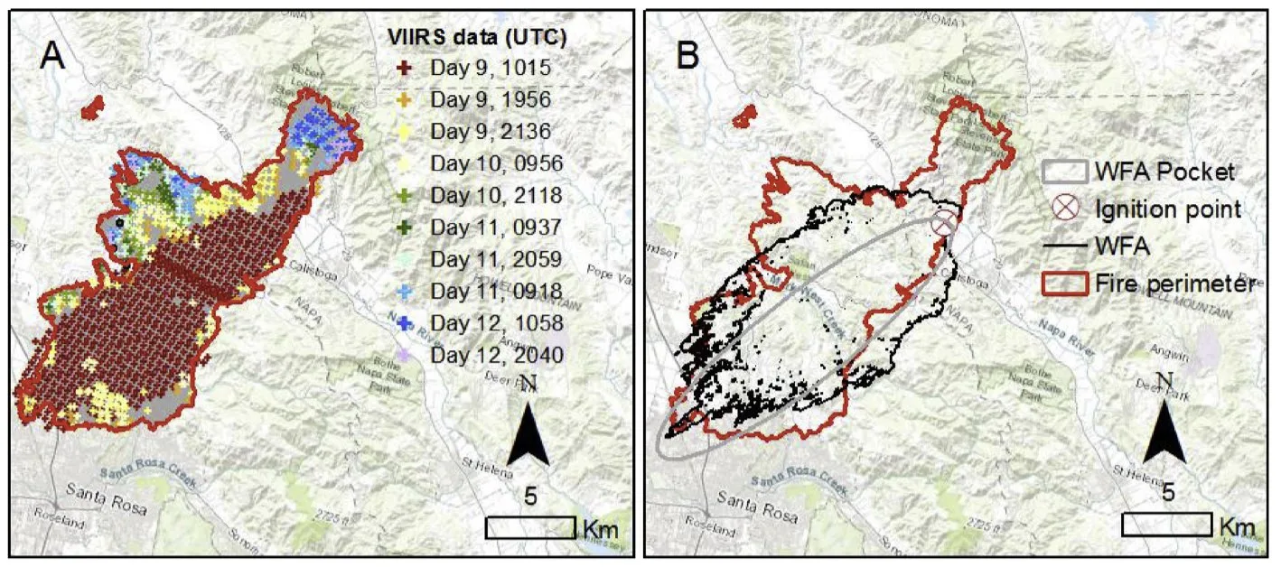
A case study involving the Tubbs Fire demonstrated how WFA Pocket accurately predicted fire behavior, especially in the head of the fire. It estimated a mean rate of spread similar to the actual fire spread. However, it’s essential to note that the accuracy of fire simulations depends on factors like model limitations, input data quality, and the level of spatial variability in the conditions.
Next Steps from the Research
WFA Pocket is a valuable tool for predicting fire behavior in real-time in the field. It provides accurate results and is suitable for a wide range of research and fire management applications. While it has limitations and assumptions, future improvements could enhance its accuracy and capabilities for analyzing fire progression across varying landscapes.
Learn more about how this science is put into practice.

-
A First Time Validation of Fire Spread Modeling on the Fire Line
Despite California being a major fire hotspot in the Americas, there is no extensive scientific analysis of operational fire spread models allowing analysis of their performance and drivers leading to model inaccuracies. Recent advances in technology have allowed monitoring the fire progression of most wildfires every 15 min in the United States through the National Fireguard Detections platform. This data, when available for use on a fire, provides unprecedented capabilities to analyze factors influencing fire behavior and compare the observed and predicted wildfire rate-of-spread (ROS) modeling in fires distributed across different and complex landscapes.
Building on other studies that analyzed these modeling techniques, Technosylva joined with CALFIRE and led a 2023 peer-reviewed study, published in the International Journal of Wildland Fire that assesses the performance of fire spread models used in California by comparing observed fire growth data with simulated data. The analysis reviewed operational settings under different environmental conditions using 1853 California wildfires from 2019 to 2021 to determine what conditions the current models may over, or underestimate ROS and subsequently, the burned area and associated fire impacts on buildings and other assets.
“It was a great opportunity to analyze these fires because it’s the first time we have had such a data set with its huge number of files and additionally, temporal resolution of that data in polygons every 15 minutes. So, it is unprecedented to have both this amount of fire monitoring data and a fire behavior simulator platform with high-quality inputs, including the fuel types, the weather conditions, canopy characteristics, and other pieces.
The analysis allowed us the opportunity to compare the best fire modeling possible with the best fire monitoring possible. The main conclusion from the analysis was that these models can be used in wildfire operational environments.”

Adrián Cardil, Ph. D
Lead Author & Senior Fire Researcher
Insight from the Research
Wildfire spread models play a crucial role in predicting how fires propagate, but their accuracy is influenced by various factors, including fuel availability, topography, and weather. Among these models, Rothermel’s semi-empirical model has been widely used for its simplicity and computational efficiency. However, the inherent limitations and assumptions of these models, along with input data quality, can impact their reliability.
This study, conducted in California, aimed to assess the predictive accuracy of wildfire spread models under different environmental conditions. It utilized high-resolution data from the National Fireguard Detections product to compare observed and predicted Rates of Spread (ROS) for 1853 wildfires occurring from 2019 to 2021. The analysis sought to identify conditions under which the models overestimate or underestimate ROS, ultimately affecting the burned area and fire impacts on buildings and assets.

Cite: Adrián Cardil Key observations and findings from the Research
- Fire Progression Data: The study used the National Fireguard Detections product data, offering high temporal resolution to monitor fire progression every 15 minutes. A grid-growing clustering algorithm was employed to classify polygons into individual fire incidents, enabling a quantitative analysis of fire behavior.
- Fire Modeling with WFA-e: Fire simulations were conducted using WFA-e, incorporating various fire spread models, including Rothermel’s surface and crown fire spread models. Fuel type, topography, and weather data were integrated to run simulations.
- Statistical Analysis: The accuracy of the fire spread models was assessed using error metrics such as ROS residuals, mean absolute error (MAE), mean bias error (MBE), and mean absolute percentage error (MAPE).
- Environmental Factors: The study revealed that the accuracy of fire spread predictions was influenced by environmental variables such as wind speed and fuel moisture content (both live and dead). Low wind speeds and high fuel moisture levels tended to lead to underestimations of ROS, while high wind speeds resulted in overestimations.
- Fuel Types: Different fuel types played a significant role in the accuracy of predictions. Models performed relatively well for shrub, grass, and grass-shrub fuel types, while they consistently underpredicted ROS for timber fuel types.
- Overall Model Accuracy: The models had an average MAPE of 47% for automatic fire simulations, with better performance in shrub, grass, and grass-shrub fuel types. Timber fuel types exhibited the highest MAPE (approximately 67%).
The study found that the model errors and biases were reasonable for simulations performed automatically. It identified environmental variables that might bias ROS predictions, particularly in timber areas where some fuel models might underestimate ROS. Overall, the performance of fire spread models for California aligns with studies developed in other regions, and the models are deemed accurate enough to be used in real-time to assess initial attack fires.
Next Steps from the Research
The study highlighted challenges related to pyroconvection, local wind fields, and the estimation of ROS in timber areas. It recommended the development of improved fire spread models to address these challenges and enhance prediction accuracy.
The study found that while current fire spread models have limitations and biases, they are accurate enough to be used in real-time operational settings, particularly with the capability for manual adjustments and calibration. However, there is a need for ongoing improvements, especially for modeling fire spread in timber areas, predicting crown fire behavior, and considering the effects of pyroconvection. This research contributes valuable insights to wildfire prediction and management, emphasizing the importance of continuously refining and enhancing predictive models in the face of growing wildfire threats.
The research underscores the importance of wildfire simulators in supporting planning and incident analysis in real-time, despite the potential uncertainties derived from input data quality and model inaccuracies. The study additionally provides insights into the performance of fire spread models in California, offering a foundation for understanding and potentially improving upon current operational models in the future.